
There is a new nation, selfhypnotized to be the same and unaltered with an ancient one, bearing the same name, and for that reason often believed to be such, whose “prominent” sons are struggling to promote their “noble and genuine” descent. These “devoted sons” are using any mean, despite being true or false, they are combining and connecting any reliable or abusive information, linking in one whole account, weak evidences or unrelated stories and often combined with their own desires is what they use . This is made possible through the speculation, subjectivism, untraceable presumption or thesis, and always ignoring alternatives and evidences which go against their interest. These guys are now called Modern Hellenes or Greeks, their country is being called Modern Greece, borrowing the name of an ancient entity, which nobody knows what was representing, or even if really existed or not, but “its sons” are doing their best, to convince the opinion and especially themselves on the truthiness of their fairytale, or in the best case close to very vague.
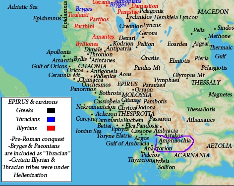
Among others one instrument being used is the maps . The maps are always considered very effective tool, to show or to summarize chaotic information about lands, people and ethnic distribution, but when those fall to the wrong hands, they are used to promote abusive, speculative information, carefully altered or selected to alter the real image to a false one, using well elaborated thesis from nationalistic and propagandistic lobbies or clans . When you look at their maps, your first impression is that they bring overwhelming evidences, and they show a tabloid close to reality, but they are not, their main function is to fulfill the mission carried by unscrupulous people, a mission which often goes against the truth and intentionally but carefully alters that truth, in order to be reliable. A map of this kind is the following one:
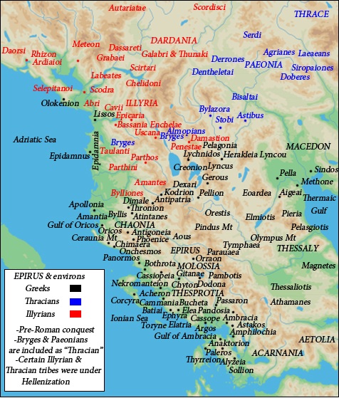
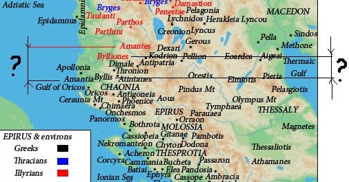
When the map’ creator marks on the entire Ancient Epirus on the map as Greek and not Ancient Greek, he is automatically suggesting that this land has been inhabited since ancient times by Greeks, and the current inhabitants, which means the Albanians, are somehow foreigners to it. This map has been created to legitimize the chauvinistic pretenses raised since Greek state creation to claim this land as theirs, upon this ancient historical territory “rightfully” belonging only to the Greeks, which according them is “stolen” by the ‘barbaric” Albanians in a later time. The later are often seen as not connected neither to Epirotes nor to Illyrians, in some extreme Greek political environments where the map’ creator belongs to.
What map’ creator is failing to provide to us, is the connection between Ancient Greeks and Modern ones, since he is implying this, using the word ‘Greeks’ instead of the more acceptable: Ancient Hellenes. If he would suggest the language as ultimate evidence in favor of Greek continuity, I will easily dismiss this evidence, since not only Ancient Greek is structurally, grammatically, phonetically very different from Modern one, but also we all know how the “Greek” language became the language of the current Greeks, not through the family hearth, not in the rural “Greece”, but always where Church and administrative powers were applied, and especially where the Byzantine merchants were established, speaking the non-vernacular official language of their empire, the Medieval Greek.
The ethnicity of the Epirotes is largely accepted barbarous which means non-Greek. It’s been only few individuals among the scholars who suggested that Epirotes might have been Greek speakers, but their arguments are very debatable. The meaning of the ethnicity in the ancient times was very different from the modern one, so the chances are great that for that kind of meaning, the ethnicity of Epirotes was not Greeks in a strict way, but even if some quotes give for them some connections to the Greeks, the evidences offered until now, to support this theses are often indirect, few in numbers, vague and thus unreliable. Being so, no serious scholar has the luxury to claim all Epirotes, and among them some combined Illyro-Epirote tribes as Greeks. This is nothing but speculation, until the map’ creator brings forward much more evidences in the favor of his thesis.
When it comes to the language spoken by Epirotes has been implied as Greek by the map creator, and supported only from the inscriptions found on a limited number of archeological artifacts such as coins, tablets, steles etc most of which are found where ancient Greek colonies were established, and almost never in a rural Epirotic area.
The truth is that very few scholars are suggesting Epirotic language to be a form of Greek. Let’s grant the pleasure to them for now, ‘admitting’ that Epirotes were using Greek, but if so, what about uncountable coins, steles, tablets from Illyria where inscriptions found on artifacts were Greek, and not only around places where Greek colonies had been built, but everywhere, even in the most remote Illyrian cities, far from Greek influence? The excuse that only the Illyrian elite was using the Greek language is just such, otherwise it must be applied for the Epirotic elite too, making null the argument that entire population of Epirus had been speaking Greek. So the selective reasoning of these scholars is just another speculation., making inevitable the falsity of their arguments and the map where those pseudo arguments are synthesized on.
The argument of the artifacts found in Epirus where some inscription written in Greek makes this land a Greek one, is ridiculous, Greek artifacts are found with abundance all over the Mediterranean, but that doesn’t make this vast area as Greek and vulnerable to the Greek pretenses.
Because the Illyrians have been proved to inhabit a very large area, most of it far away from the Greek influence, they “escape” the desire of Greek propaganda to claim them as Greeks. This fits another goal , it serves as comparison to promote the superior “Greek” culture against neighbors’ one, a culture often announced as inferior from the same sources. So Greek propaganda is claiming only the Illyrians as non-Greek-speakers, while Epirotes and Macedonians as Greeks.
Now let’s compare some quotes from both sides of the supporters. Let’s start with those who support Greekness of the Epirotes:
This “evidence” must be considered irrelevant, since the ethnicity of the king does not determine the entire population ethnicity, furthermore the ethnicity of this individual was believed and perhaps desired from the Greek authors to be such, since he was believed a descendent of Achilles(and Aecides), whose ethnicity was unclear itself but most likely Pelasgic, and more than 900 years separate the timelife of each other.
The following quote must considered irrelevant too:

it gives no meaningful clue to determine the ethnicity of the Epirotes, since the term ‘Hellada’ was used in a geographical prospective, and deliberately “confused” to the political-ethnical meaning it has today. Also we have quotes from other Greek authors, which completely annul the above, since they are direct and not vague like the above:
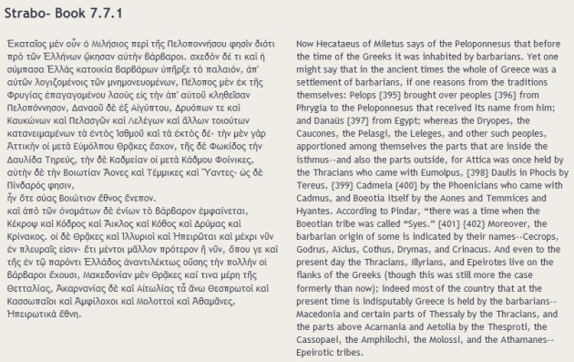
Strabo 008.001.003
28. CHAONES. And after Illyrians, Chaonians. And Chaonia has good harbours: and the Chaonians live in villages. And the coastal voyage of Chaonia is a half of a day.
29. KORKYRA. And by Chaonia is an island, Korkyra, and a Hellenic city in it, having three harbours by the city: of these the one is enclosed. And Korkyra belongs also to Thesprotia morethan Chaonia. And I return again onto the mainland, whence I turned aside.
30. THESPROTIANS. And after Chaonia are the Thesprotian nation. And these too live in villages: and this territory also has good harbours. Here is a harbour, which has name Elaia. Intothis the harbour the river Acheron emits: and there is lake Acherousia, out of which the Acheronfiver flows. And the coastal voyage of Thesprotias is a half of a day
31. KASSOPIANS. And after Thesprotia is the nation Kassopia. And these too live in villages. And these live beside as far as into the Anaktoric gulf. And the coastal voyage of the Kassopians’ territory is a half of a day; and the Anaktoric gulf is a little less from its mouth as faras into the inner end, 120 stades. And the mouth has width 4 stades.
32. MOLOTTIA. And after Kassopia are the Molottian nation. And these live in villages: andthey come down only a little here to the sea, and largely into the interior. And the coastal voyage of Molotia is 40 Stades
33. AMBRAKIA. And after Molottia, Ambrakia, a Hellenic city: and this is distant from sea 80 stades. And there is also upon the sea a fort and an enclosed harbour. From here Hellas begins to be continuous as far as Peneios river and Homolion, a city of Magnesian territory, which is beside the river. And the coastal voyage of Ambrakia is of 120 stades.
The Greek propaganda often makes equivalent the meaning of nation, state or ethnicity in ancient time to these in the modern one, which by no means resembles the former, at least for the mysterious Ancient Greeks, who never used to live in an homogeneous ethnically continues territory. From the accounts we have from the antiquity they used to live in polises(city-states) and often mixed up with barbarians(non-Greeks), who are called so from the Ancient “”Greeks”” themselves:
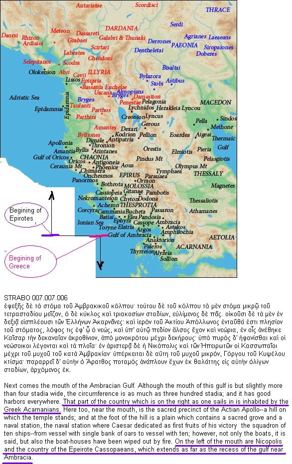
Thucydides makes a clear division between Hellenes and Epirotes explicitly claiming them as Barbarians, a word back in time meaning non-Greek.
The Greek propaganda could insist that this must be an error by Thucydides, but unfortunately no. Strabo was even clearer. He definitely reinforces Thucydides position, not only claiming them as non-Greeks but also separating them geographically:
The meaning of the ethnicity in regards to the ancient ethnoses(nations) is a complex one, and should not be viewed like ‘black and white’. The ‘colors’ on this view, make us understand that the Epirotes and the Ancient Greeks were relatives, but the ethnical distance between them was larger than that between the Epirotes and the Illyrians. The Illyrians too were close relatives to the Ancient Hellenes, but by no means the later are related in any aspect to the Modern Greeks.
Now let’s return to the map to show the numerous distortions and speculations made from the mastermind behind it.
Epirus’ area on the map is intentionally colored by black spots(which means Greek), most of which represents cities’ names. These cities had been only TEMPORARY inhabited by Greek merchants and their families, and by no means represent the tribes of Epirus.
A colony does not represent an original ethnic territory, but is often distant from it, and a colonist is not a genuine inhabitant of the land or an autochthon. Let’s take the example of the ancient city of Apollonia. The first Greek colonists settled there only in 588 BCE and finished being expelled from land, by the native Illyrians around 200 hundred years later, and in the 229 BCE became a Roman city. So the Greek portion in the history of that land was short, limited and not exclusive, thinking that even during that dominance from the Greeks, the natives who were the Taulantian Illyrians had a prominent part in its history.
Greek propaganda is eager to show a short-lived Greek city as Apollonia on the map
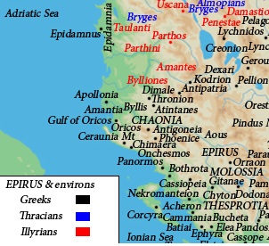
but deliberately fails to mark that at least the surrounding area was an Illyrian land much longer before and after the Greek lifetime city. The following quote is taken from the book of the geographer of the 6th century BCE Skylax of Karyanda, where he mentions Apollonia as a Greek city in the Illyrian land, contrary to the map above which creates an illusion that the nearest Illyrian tribe lives far from this land.
This land was Illyrian because were inhabited from the Illyrian TAULANTII(Ταυλάντιοι), who are placed much further north by the map creator, while that position is just the start point of their dominance which ends in the surrounding Apollonia: This is one of many cases where accuracy has been intentionally badly compromised by the map’ creator, to the limits of a falsity.
Taulantii are not the only Illyrian tribe ‘pushed’ upper North, so are the Amantians. In the map the Oricii who lived in the Amantian territory are ridiculously presented way far from them:
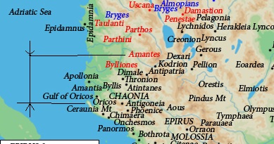
While ancient authors have already confirmed that Oricii who are positioned at the feet of Ceraunia Mt. are the inhabitants of the Amantian land.
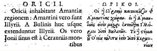
and Amantes are Illyrians
27.ORIKOI. And the Orikoi occupy of the Amantian territory.] And the Amantians, from Boulinoi as far as here, are Illyrians. And the mouth of the Ionian gulf is from Keraunian mountains as far as cape Iapygia.
This is a huge distortion from the individual who created this map, but his deeds are not finished yet. He intentionally detaches Amantes from their capital Amantia and Bylliones(or Hylliones) from their capital Byllis:
where obviously Amantia and Byllis must be part and should have been included within respective land of Illyrian Amantes and Illyrian Bylliones.
But this doesn’t seem to be the last “deed” of map’ creator. In his mission distorting the truth he ‘gave’ to Bylliones or Hyllinoi( Hylleasit or Hyllinet in Albanian language) only a small piece of territory in his map. But this Illyrian tribe, who sprang Hyllus the son of Heracles and the patriarch of the purest Hellenic tribe, the noblest Dorian Hylloi( Ὑλλέας ):
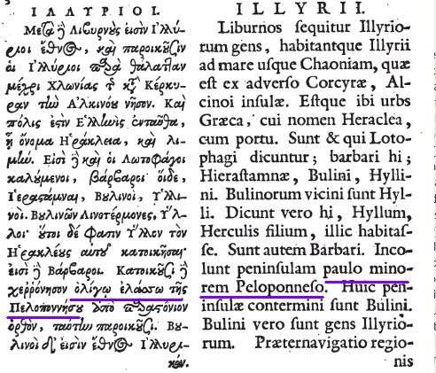
22. ILLYRIOI. And after Libyrnians are the Illyrian nation, and the Illyrians live along beside the sea as far as Chaonia by Kerkyra, the island of Alkinoös. And there is a Hellenic city here, which has the name Herakleia, with a harbour. The barbarians called Lotus-eaters are the following: Hierastamnai, Boulinoi (Hyllinoi), coterminous with Boulinoi the Hylloi. And these say Hyllos son of Herakles settled them: and they are barbarians. And they occupy a peninsula a little lesser than the Peloponnese. And from peninsula parastonion* is upright: Boulinoi live beside this. And Boulinoi are an Illyric nation. And the coastal voyage is of the territory of Boulinoi of a long day up to Nestos rive
So the Bylliones alone occupy a land ‘little lesser’ than Peloponnese:
which is 21,549 km²(the entire Albania today is only 28,748 km2). If this statement is correct then the limits of their real territory would have been deep in Epirus and Macedonia .
We know that some of the Epirotic tribes [marked as Greek(in black) by the map’ author] were intermingled with Illyrians:
Strabo 007.007.008
a good indication that Illyrians and Epirotes must have been similar in language and manners, while we don’t have any confirmation that at least one Epirotic tribe was intermingled with the Greeks.
When you look at the map where all Epirotes are claimed as Greeks,
one obviously would expect all these people had spoken Greek, and more southern you go much more these expectations should increase. Following this reasoning let’s look at the most southern tribe: the Amphiloci, who according Strabo were Epirotes:
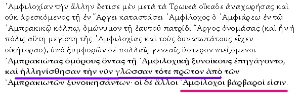
About the same time towards the close of the summer, the Ambraciot forces, with a number of barbarians that they had raised, marched against the Amphilochian Argos and the rest of that country. The origin of their enmity against the Argives was this. This Argos and the rest of Amphilochia were colonized by Amphilochus, son of Amphiaraus. Dissatisfied with the state of affairs at home on his return thither after the Trojan war, he built this city in the Ambracian gulf, and named it Argos after his own country. This was the largest town in Amphilochia, and its inhabitants the most powerful. Under the pressure of misfortune many generations afterwards, they called in the Ambraciots, their neighbors on the Amphilochian border, to join their colony; and it was by this union with the Ambraciots that they learnt their present Hellenic speech, the rest of the Amphilochians being barbarians.
”Surprisengly” it says that those people have not had the Greek their natural language, [even though they came from the heart of Greece ARGOS(in Peloponnesus) the famous capital of Argives(or Achaeans) who were the one who attacked Troy , known as Greeks who ….do not speak Greek (????)] only part of them learned the language only when they were mixed with the Greek colonists of Ambrakia, the rest of Amphilocians remained genuine, barbaroi, meaning non-Greeks, and never unlearnt their original language.
So the inhabitants of Argos and Amphilocia, the two cities founded from an Argive fighter, returning back from the Trojan War, didn’t speak Greek on the first place, that means that the participant of the Trojan War, Achaeans or Danans, largely considered as Greeks weren’t such at all.
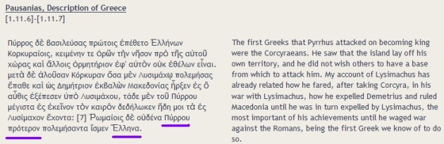
The “deeds” on this map are uncountable, it represents Atintanes as Greeks, while all quotes from antiquity show them a tribe between Illyrians and Epirotes both barbaroi(non-Greeks). This map tells us that a very important tribe like Brygi, are Thracians only (in incapability to claim them as Greeks) but Brygi were at least partially Illyrians(*). To this point the above map shows itself completely incorrect, and it deserves only a place, the trash bin. This is the rightful place for it, since it not only dissinform the public, not only plays with the history facts, but most of all it has been purposely constructed in such way that some people to take credits belonging to the others. We don’t know much about real ethnicity of ancient Epirotes, but what we know is that the “mastermind” behind the map is not trying to shed some light in it, he is otherwise trying to hide and alter the truth. What we do know about ancient Epirotes is that they were different from authentic Hellenes, by name, style of life, manners, speech, political organization, territory and everything that distinguish two nations from one another, if this is the proper word to describe the so called Hellenes and Epirotes. We also know for fact the meaning of Epirus during Medieval Time, it was synonym to the Albania, that is the reason in this map of 1600 AD(and not only in this) Epirus is called: Epirus quæ hodie Albania
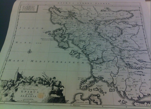
which means: Epirus , Albania itself today
And at the top : Epirus Pyrrhi patria, or in English, Epirus Pyrrhys homeland.
This is the reason why in this other Latin map:
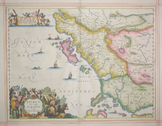
We find the title ‘Epirus hodie vulgo Albania’ which means: Epirus, now called Albania.
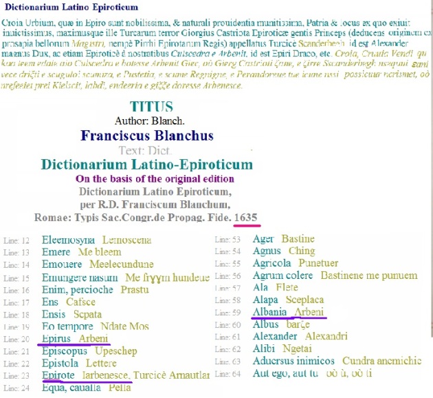
This is the reason why Franciscus Blanchus in his dictionary of 1635: Latin-Epiroticum Dictionary which means Latin-Albanian translates Epirus as Albania, or Arbëria in the Epirotic(Albanian) language. He also identifies clearly an Epirote as an Arbenesh, who means Albanian in the language of its inhabitants.
That is the reason that even the Old Epirus has been translated as Albania from Latin language to Italian, from the translator Lodovico Domenichi in the year 1515 AD, the text written from Pliny the Elder taken from his book 3 chapter 26/23
(23.) At Lissum begins the province of Macedonia , the nations of the Parthini , and behind them the Dassaretæ . The mountains of Candavia are seventy-eight miles from Dyrrhachium. On the coast lies Denda, a town with the rights of Roman citizens, the colony of Epidamnum , which, on account of its inauspicious name, was by the Romans called Dyrrhachium, the river Aöus , by’ some called Æas, and Apollonia , formerly a colony of the Corinthians, at a distance of four miles from the sea, in the vicinity of which the celebrated Nymphæum is inhabited by the barbarous Amantes and Buliones. Upon the coast too is the town of Oricum , founded by the Colchians. At this spot begins Epirus, with the Acroceraunian mountains, by which we have previously mentioned this Gulf of Europe as bounded. Oricum is distant from the Promontory of Salentinum in Italy eighty miles.
Contrary to the Croats who were trying to call their country Illyria, because it matches partially the territories of this old nation, Albanians never called their land Epirus, it SPONTANEOUSLY had been called like this from the others, which reinforces the argument that Albania is the old Epirus, and its inhabitants are descendents of the ancient Epirotes. Albanians never made any attempt to artificially associate their name to Epirus, like Greeks desperately are doing nowadays since the others created their unnatural state , raising hundred of political organizations, named Greek- Epirotic League, or Panepirotic Federation, etc. etc in the most remote places of the World, trying till the exhaust to join artificially two things that exclude each-other : a Greek and an Epirote.
An Epirote is another name for an Albanian, and it will remain so generation after generation.
The END
Among others one instrument being used is the maps . The maps are always considered very effective tool, to show or to summarize chaotic information about lands, people and ethnic distribution, but when those fall to the wrong hands, they are used to promote abusive, speculative information, carefully altered or selected to alter the real image to a false one, using well elaborated thesis from nationalistic and propagandistic lobbies or clans . When you look at their maps, your first impression is that they bring overwhelming evidences, and they show a tabloid close to reality, but they are not, their main function is to fulfill the mission carried by unscrupulous people, a mission which often goes against the truth and intentionally but carefully alters that truth, in order to be reliable. A map of this kind is the following one:

A map that had found the way through the pages of a respected encyclopedia website Wikipedia, which unfortunately is full of unreliable and speculative unfiltered information, loosing its main goal to inform the public in an impartial way and always showing the alternative outlooks, which telling the truth is not missing in regards of this subject.
The map is placed in the page about Epirus region, and shows extreme opinions, about how was composed Ancient Epirus and Illyria. The reason why Wikipedia hadn’t filtered the information
displayed in this map, or why had not given an alternative to this, is very fishy, but it is a well known fact that some exponents of Greek propaganda enjoy high ranks within Wikipedia’s moderators team, a situation suspiciously tolerated from organization leaders.
The map not leaving room for alternatives, shows a black and white tabloid, it represents or at least tries to impose the illusion that the entire Epirus and most of Southern Illyria has been inhabited homogeneously only from the Greek tribes. We will prove that this is just an illusion and the accounts coming to us from antiquity show a totally different situation.When the map’ creator marks on the entire Ancient Epirus on the map as Greek and not Ancient Greek, he is automatically suggesting that this land has been inhabited since ancient times by Greeks, and the current inhabitants, which means the Albanians, are somehow foreigners to it. This map has been created to legitimize the chauvinistic pretenses raised since Greek state creation to claim this land as theirs, upon this ancient historical territory “rightfully” belonging only to the Greeks, which according them is “stolen” by the ‘barbaric” Albanians in a later time. The later are often seen as not connected neither to Epirotes nor to Illyrians, in some extreme Greek political environments where the map’ creator belongs to.
What map’ creator is failing to provide to us, is the connection between Ancient Greeks and Modern ones, since he is implying this, using the word ‘Greeks’ instead of the more acceptable: Ancient Hellenes. If he would suggest the language as ultimate evidence in favor of Greek continuity, I will easily dismiss this evidence, since not only Ancient Greek is structurally, grammatically, phonetically very different from Modern one, but also we all know how the “Greek” language became the language of the current Greeks, not through the family hearth, not in the rural “Greece”, but always where Church and administrative powers were applied, and especially where the Byzantine merchants were established, speaking the non-vernacular official language of their empire, the Medieval Greek.
The ethnicity of the Epirotes is largely accepted barbarous which means non-Greek. It’s been only few individuals among the scholars who suggested that Epirotes might have been Greek speakers, but their arguments are very debatable. The meaning of the ethnicity in the ancient times was very different from the modern one, so the chances are great that for that kind of meaning, the ethnicity of Epirotes was not Greeks in a strict way, but even if some quotes give for them some connections to the Greeks, the evidences offered until now, to support this theses are often indirect, few in numbers, vague and thus unreliable. Being so, no serious scholar has the luxury to claim all Epirotes, and among them some combined Illyro-Epirote tribes as Greeks. This is nothing but speculation, until the map’ creator brings forward much more evidences in the favor of his thesis.
When it comes to the language spoken by Epirotes has been implied as Greek by the map creator, and supported only from the inscriptions found on a limited number of archeological artifacts such as coins, tablets, steles etc most of which are found where ancient Greek colonies were established, and almost never in a rural Epirotic area.
The truth is that very few scholars are suggesting Epirotic language to be a form of Greek. Let’s grant the pleasure to them for now, ‘admitting’ that Epirotes were using Greek, but if so, what about uncountable coins, steles, tablets from Illyria where inscriptions found on artifacts were Greek, and not only around places where Greek colonies had been built, but everywhere, even in the most remote Illyrian cities, far from Greek influence? The excuse that only the Illyrian elite was using the Greek language is just such, otherwise it must be applied for the Epirotic elite too, making null the argument that entire population of Epirus had been speaking Greek. So the selective reasoning of these scholars is just another speculation., making inevitable the falsity of their arguments and the map where those pseudo arguments are synthesized on.
The argument of the artifacts found in Epirus where some inscription written in Greek makes this land a Greek one, is ridiculous, Greek artifacts are found with abundance all over the Mediterranean, but that doesn’t make this vast area as Greek and vulnerable to the Greek pretenses.
Because the Illyrians have been proved to inhabit a very large area, most of it far away from the Greek influence, they “escape” the desire of Greek propaganda to claim them as Greeks. This fits another goal , it serves as comparison to promote the superior “Greek” culture against neighbors’ one, a culture often announced as inferior from the same sources. So Greek propaganda is claiming only the Illyrians as non-Greek-speakers, while Epirotes and Macedonians as Greeks.
Now let’s compare some quotes from both sides of the supporters. Let’s start with those who support Greekness of the Epirotes:

This “evidence” must be considered irrelevant, since the ethnicity of the king does not determine the entire population ethnicity, furthermore the ethnicity of this individual was believed and perhaps desired from the Greek authors to be such, since he was believed a descendent of Achilles(and Aecides), whose ethnicity was unclear itself but most likely Pelasgic, and more than 900 years separate the timelife of each other.
The following quote must considered irrelevant too:

it gives no meaningful clue to determine the ethnicity of the Epirotes, since the term ‘Hellada’ was used in a geographical prospective, and deliberately “confused” to the political-ethnical meaning it has today. Also we have quotes from other Greek authors, which completely annul the above, since they are direct and not vague like the above:
Strabo 008.001.003
Ἔφορος μὲν οὖν ἀρχὴν εἶναι τῆς Ἑλλάδος τὴν Ἀκαρνανίαν φησὶν ἀπὸ τῶν ἑσπερίων μερῶν· ταύτην γὰρ συνάπτειν πρώτην τοῖς Ἠπειρωτικοῖς ἔθνεσιν.So thinks Pseudo-Skylaks too:
Ephorus says that, if one begins with the western parts, Acarnania is the beginning of Greece; for, he adds, Acarnania is the first to border on the tribes of the Epeirotes
28. CHAONES. And after Illyrians, Chaonians. And Chaonia has good harbours: and the Chaonians live in villages. And the coastal voyage of Chaonia is a half of a day.
29. KORKYRA. And by Chaonia is an island, Korkyra, and a Hellenic city in it, having three harbours by the city: of these the one is enclosed. And Korkyra belongs also to Thesprotia morethan Chaonia. And I return again onto the mainland, whence I turned aside.
30. THESPROTIANS. And after Chaonia are the Thesprotian nation. And these too live in villages: and this territory also has good harbours. Here is a harbour, which has name Elaia. Intothis the harbour the river Acheron emits: and there is lake Acherousia, out of which the Acheronfiver flows. And the coastal voyage of Thesprotias is a half of a day
31. KASSOPIANS. And after Thesprotia is the nation Kassopia. And these too live in villages. And these live beside as far as into the Anaktoric gulf. And the coastal voyage of the Kassopians’ territory is a half of a day; and the Anaktoric gulf is a little less from its mouth as faras into the inner end, 120 stades. And the mouth has width 4 stades.
32. MOLOTTIA. And after Kassopia are the Molottian nation. And these live in villages: andthey come down only a little here to the sea, and largely into the interior. And the coastal voyage of Molotia is 40 Stades
33. AMBRAKIA. And after Molottia, Ambrakia, a Hellenic city: and this is distant from sea 80 stades. And there is also upon the sea a fort and an enclosed harbour. From here Hellas begins to be continuous as far as Peneios river and Homolion, a city of Magnesian territory, which is beside the river. And the coastal voyage of Ambrakia is of 120 stades.

The Greek propaganda often makes equivalent the meaning of nation, state or ethnicity in ancient time to these in the modern one, which by no means resembles the former, at least for the mysterious Ancient Greeks, who never used to live in an homogeneous ethnically continues territory. From the accounts we have from the antiquity they used to live in polises(city-states) and often mixed up with barbarians(non-Greeks), who are called so from the Ancient “”Greeks”” themselves:

Thucydides makes a clear division between Hellenes and Epirotes explicitly claiming them as Barbarians, a word back in time meaning non-Greek.
The Greek propaganda could insist that this must be an error by Thucydides, but unfortunately no. Strabo was even clearer. He definitely reinforces Thucydides position, not only claiming them as non-Greeks but also separating them geographically:

The meaning of the ethnicity in regards to the ancient ethnoses(nations) is a complex one, and should not be viewed like ‘black and white’. The ‘colors’ on this view, make us understand that the Epirotes and the Ancient Greeks were relatives, but the ethnical distance between them was larger than that between the Epirotes and the Illyrians. The Illyrians too were close relatives to the Ancient Hellenes, but by no means the later are related in any aspect to the Modern Greeks.
Now let’s return to the map to show the numerous distortions and speculations made from the mastermind behind it.
Epirus’ area on the map is intentionally colored by black spots(which means Greek), most of which represents cities’ names. These cities had been only TEMPORARY inhabited by Greek merchants and their families, and by no means represent the tribes of Epirus.
A colony does not represent an original ethnic territory, but is often distant from it, and a colonist is not a genuine inhabitant of the land or an autochthon. Let’s take the example of the ancient city of Apollonia. The first Greek colonists settled there only in 588 BCE and finished being expelled from land, by the native Illyrians around 200 hundred years later, and in the 229 BCE became a Roman city. So the Greek portion in the history of that land was short, limited and not exclusive, thinking that even during that dominance from the Greeks, the natives who were the Taulantian Illyrians had a prominent part in its history.
Greek propaganda is eager to show a short-lived Greek city as Apollonia on the map

but deliberately fails to mark that at least the surrounding area was an Illyrian land much longer before and after the Greek lifetime city. The following quote is taken from the book of the geographer of the 6th century BCE Skylax of Karyanda, where he mentions Apollonia as a Greek city in the Illyrian land, contrary to the map above which creates an illusion that the nearest Illyrian tribe lives far from this land.

Ἀπολλωνία. α΄ πόλις Ἰλλυρίας, ἣν ᾤκουν Ἰλλυριοί, κατ’ Ἐπίδαμνον. ὕστερον διακοσίων Κορινθίων ἀποικία εἰς αὐτὴν ἐστάλη, ἧς ἡγεῖτο Γύλαξ, ὃς Γυλάκειαν ὠνόμασε. τὸ ἐθνικὸν Ἀπολλωνιάτης καὶ θηλυκὸν Ἀπολλωνιᾶτις. β΄ ἐν νήσῳ πρὸς τῇ Σαλμυδησσῷ, ἀποικία Μιλησίων καὶ Ῥοδίων. γ΄ Μακεδονίας. δ΄ πόλις Λιβύης. ε΄ ἐν νήσῳ τῆς Ἀκαρνανίας, μία τῶν Ἐχινάδων. Ϛ΄ ἐν Κρήτῃ πρὸς τῇ Κνωσσῷ. ζ΄ πλησίον Ἀλοντίνων καὶ Καλῆς ἀκτῆς. η΄ Μυσίας. θ΄ πόλις Μυσίας ἐπὶ Ῥυνδάκῳ ποταμῷ. ι΄ κατὰ Θυάτειρα καὶ Ἔφεσον. ια΄ Φωκίδος, ἣν Ὅμηρος Κυπάρισσόν φησι, διὰ τὸ πολλὰς ἔχειν κυπαρίσσους, ὡς Δίδυμος. ιβ΄ περὶ τὴν κοίλην Συρίαν. ιγ΄ κατὰ Ἰόπην. ιδ΄ τῆς Μεσοποταμίας. ιε΄ Λιβύης, ἣ Κυρήνη ἐκαλεῖτο. ιϚ΄ Λυδίας. ιζ΄ Πισιδίας, ἡ πρότερον Μορδιάιον. ιη΄ Φρυγίας, ἡ πάλαι Μάργιον. ιθ΄ ἐν Σίφνῳ τῇ νήσῳ. κ΄ Συρίας κατὰ Ἀπάμειαν. κα΄ νῆσος πρὸς τῇ Λυκίᾳ. κβ΄ τῶν ἐπὶ Θρᾴκης Ἰώνων, ἣν Δημοσθένης φησίν. κγ΄ Κρήτης, ἡ πάλαι Ἐλεύθερνα, Λίνου πατρίς. ἐκ ταύτης ὁ φυσικὸς Διογένης. κδ΄ ἐν Αἰγύπτῳ. κε΄ μεταξὺ Βαβυλῶνος καὶ Σούσων. Τρύφων ἐν τῷ περὶ παρωνύμων τὸ ἐθνικὸν εἶπεν Ἀπολλωνιεύς· ἀλλ’ οὐκ ἔστιν ἐκ τῆς πόλεως, ἀλλ’ ἐκ τοῦ Ἀπολλώνιον, ὡς Δουλίχιον Δουλιχιεύς.
This land was Illyrian because were inhabited from the Illyrian TAULANTII(Ταυλάντιοι), who are placed much further north by the map creator, while that position is just the start point of their dominance which ends in the surrounding Apollonia: This is one of many cases where accuracy has been intentionally badly compromised by the map’ creator, to the limits of a falsity.
Taulantii are not the only Illyrian tribe ‘pushed’ upper North, so are the Amantians. In the map the Oricii who lived in the Amantian territory are ridiculously presented way far from them:

While ancient authors have already confirmed that Oricii who are positioned at the feet of Ceraunia Mt. are the inhabitants of the Amantian land.

and Amantes are Illyrians
27.ORIKOI. And the Orikoi occupy of the Amantian territory.] And the Amantians, from Boulinoi as far as here, are Illyrians. And the mouth of the Ionian gulf is from Keraunian mountains as far as cape Iapygia.
This is a huge distortion from the individual who created this map, but his deeds are not finished yet. He intentionally detaches Amantes from their capital Amantia and Bylliones(or Hylliones) from their capital Byllis:

where obviously Amantia and Byllis must be part and should have been included within respective land of Illyrian Amantes and Illyrian Bylliones.
But this doesn’t seem to be the last “deed” of map’ creator. In his mission distorting the truth he ‘gave’ to Bylliones or Hyllinoi( Hylleasit or Hyllinet in Albanian language) only a small piece of territory in his map. But this Illyrian tribe, who sprang Hyllus the son of Heracles and the patriarch of the purest Hellenic tribe, the noblest Dorian Hylloi( Ὑλλέας ):

22. ILLYRIOI. And after Libyrnians are the Illyrian nation, and the Illyrians live along beside the sea as far as Chaonia by Kerkyra, the island of Alkinoös. And there is a Hellenic city here, which has the name Herakleia, with a harbour. The barbarians called Lotus-eaters are the following: Hierastamnai, Boulinoi (Hyllinoi), coterminous with Boulinoi the Hylloi. And these say Hyllos son of Herakles settled them: and they are barbarians. And they occupy a peninsula a little lesser than the Peloponnese. And from peninsula parastonion* is upright: Boulinoi live beside this. And Boulinoi are an Illyric nation. And the coastal voyage is of the territory of Boulinoi of a long day up to Nestos rive
So the Bylliones alone occupy a land ‘little lesser’ than Peloponnese:

which is 21,549 km²(the entire Albania today is only 28,748 km2). If this statement is correct then the limits of their real territory would have been deep in Epirus and Macedonia .
We know that some of the Epirotic tribes [marked as Greek(in black) by the map’ author] were intermingled with Illyrians:
Strabo 007.007.008
Ἠπειρῶται δ’ εἰσὶ καὶ Ἀμφίλοχοι καὶ οἱ ὑπερκείμενοι καὶ συνάπτοντες τοῖς Ἰλλυρικοῖς ὄρεσι, τραχεῖαν οἰκοῦντες χώραν, Μολοττοί τε καὶ Ἀθαμᾶνες καὶ Αἴθικες καὶ Τυμφαῖοι καὶ Ὀρέσται Παρωραῖοί τε καὶ Ἀτιντᾶνες, οἱ μὲν πλησιάζοντες τοῖς Μακεδόσι μᾶλλον οἱ δὲ τῷ Ἰονίῳ κόλπῳ. λέγεται δὲ τὴν Ὀρεστιάδα κατασχεῖν ποτε Ὀρέστης φεύγων τὸν τῆς μητρὸς φόνον καὶ καταλιπεῖν ἐπώνυμον ἑαυτοῦ τὴν χώραν, κτίσαι δὲ καὶ πόλιν, καλεῖσθαι δ’ αὐτὴν Ἄργος Ὀρεστικόν. ἀναμέμικται δὲ τούτοις τὰ Ἰλλυρικὰ ἔθνη τὰ πρὸς τῷ νοτίῳ μέρει τῆς ὀρεινῆς καὶ τὰ ὑπὲρ τοῦ Ἰονίου κόλπου· τῆς γὰρ Ἐπιδάμνου καὶ τῆς Ἀπολλωνίας μέχρι τῶν Κεραυνίων ὑπεροικοῦσι Βυλλίονές τε καὶ Ταυλάντιοι καὶ Παρθῖνοι καὶ Βρῦγοι·
The Amphilochians are Epeirotes; and so are the peoples who are situated above them and border on the Illyrian mountains, inhabiting a rugged country–I mean the Molossi, the Athamanes, the Aethices, the Tymphaei, the Orestae, and also the Paroraei and the Atintanes, some of them being nearer to the Macedonians and others to the Ionian Gulf. It is said that Orestes once took possession of Orestias–when is, exile on account of the murder of his mother–and left the country bearing his name; and that he also founded a city and called it Argos Oresticum. But the Illyrian tribes which are near the southern part of the mountainous country and those which are above the Ionian Gulf are intermingled with these peoples; for above Epidamnus and Apollonia as far as the Ceraunian Mountains dwell the Bylliones, the Taulantii, the Parthini, and the Brygi
a good indication that Illyrians and Epirotes must have been similar in language and manners, while we don’t have any confirmation that at least one Epirotic tribe was intermingled with the Greeks.
When you look at the map where all Epirotes are claimed as Greeks,

one obviously would expect all these people had spoken Greek, and more southern you go much more these expectations should increase. Following this reasoning let’s look at the most southern tribe: the Amphiloci, who according Strabo were Epirotes:
Ἠπειρῶται δ’ εἰσὶ καὶ Ἀμφίλοχοιlet’s read a quote from Thucydides (Book 2.68)

About the same time towards the close of the summer, the Ambraciot forces, with a number of barbarians that they had raised, marched against the Amphilochian Argos and the rest of that country. The origin of their enmity against the Argives was this. This Argos and the rest of Amphilochia were colonized by Amphilochus, son of Amphiaraus. Dissatisfied with the state of affairs at home on his return thither after the Trojan war, he built this city in the Ambracian gulf, and named it Argos after his own country. This was the largest town in Amphilochia, and its inhabitants the most powerful. Under the pressure of misfortune many generations afterwards, they called in the Ambraciots, their neighbors on the Amphilochian border, to join their colony; and it was by this union with the Ambraciots that they learnt their present Hellenic speech, the rest of the Amphilochians being barbarians.
”Surprisengly” it says that those people have not had the Greek their natural language, [even though they came from the heart of Greece ARGOS(in Peloponnesus) the famous capital of Argives(or Achaeans) who were the one who attacked Troy , known as Greeks who ….do not speak Greek (????)] only part of them learned the language only when they were mixed with the Greek colonists of Ambrakia, the rest of Amphilocians remained genuine, barbaroi, meaning non-Greeks, and never unlearnt their original language.
So the inhabitants of Argos and Amphilocia, the two cities founded from an Argive fighter, returning back from the Trojan War, didn’t speak Greek on the first place, that means that the participant of the Trojan War, Achaeans or Danans, largely considered as Greeks weren’t such at all.
The “deeds” on this map are uncountable, it represents Atintanes as Greeks, while all quotes from antiquity show them a tribe between Illyrians and Epirotes both barbaroi(non-Greeks). This map tells us that a very important tribe like Brygi, are Thracians only (in incapability to claim them as Greeks) but Brygi were at least partially Illyrians(*). To this point the above map shows itself completely incorrect, and it deserves only a place, the trash bin. This is the rightful place for it, since it not only dissinform the public, not only plays with the history facts, but most of all it has been purposely constructed in such way that some people to take credits belonging to the others. We don’t know much about real ethnicity of ancient Epirotes, but what we know is that the “mastermind” behind the map is not trying to shed some light in it, he is otherwise trying to hide and alter the truth. What we do know about ancient Epirotes is that they were different from authentic Hellenes, by name, style of life, manners, speech, political organization, territory and everything that distinguish two nations from one another, if this is the proper word to describe the so called Hellenes and Epirotes. We also know for fact the meaning of Epirus during Medieval Time, it was synonym to the Albania, that is the reason in this map of 1600 AD(and not only in this) Epirus is called: Epirus quæ hodie Albania

which means: Epirus , Albania itself today
And at the top : Epirus Pyrrhi patria, or in English, Epirus Pyrrhys homeland.
This is the reason why in this other Latin map:

We find the title ‘Epirus hodie vulgo Albania’ which means: Epirus, now called Albania.
This is the reason why Franciscus Blanchus in his dictionary of 1635: Latin-Epiroticum Dictionary which means Latin-Albanian translates Epirus as Albania, or Arbëria in the Epirotic(Albanian) language. He also identifies clearly an Epirote as an Arbenesh, who means Albanian in the language of its inhabitants.

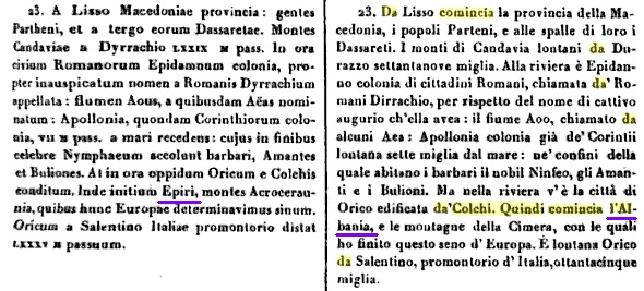
That is the reason that even the Old Epirus has been translated as Albania from Latin language to Italian, from the translator Lodovico Domenichi in the year 1515 AD, the text written from Pliny the Elder taken from his book 3 chapter 26/23

(23.) At Lissum begins the province of Macedonia , the nations of the Parthini , and behind them the Dassaretæ . The mountains of Candavia are seventy-eight miles from Dyrrhachium. On the coast lies Denda, a town with the rights of Roman citizens, the colony of Epidamnum , which, on account of its inauspicious name, was by the Romans called Dyrrhachium, the river Aöus , by’ some called Æas, and Apollonia , formerly a colony of the Corinthians, at a distance of four miles from the sea, in the vicinity of which the celebrated Nymphæum is inhabited by the barbarous Amantes and Buliones. Upon the coast too is the town of Oricum , founded by the Colchians. At this spot begins Epirus, with the Acroceraunian mountains, by which we have previously mentioned this Gulf of Europe as bounded. Oricum is distant from the Promontory of Salentinum in Italy eighty miles.
Contrary to the Croats who were trying to call their country Illyria, because it matches partially the territories of this old nation, Albanians never called their land Epirus, it SPONTANEOUSLY had been called like this from the others, which reinforces the argument that Albania is the old Epirus, and its inhabitants are descendents of the ancient Epirotes. Albanians never made any attempt to artificially associate their name to Epirus, like Greeks desperately are doing nowadays since the others created their unnatural state , raising hundred of political organizations, named Greek- Epirotic League, or Panepirotic Federation, etc. etc in the most remote places of the World, trying till the exhaust to join artificially two things that exclude each-other : a Greek and an Epirote.
An Epirote is another name for an Albanian, and it will remain so generation after generation.
The END
No comments:
Post a Comment